
Make a donation
Gear up for your next adventure:
As an Amazon Associate, this site earns from qualifying purchases at no extra cost to you.
Hekla topographic map
Click on the map to display elevation.
Make a donation
Gear up for your next adventure:
As an Amazon Associate, this site earns from qualifying purchases at no extra cost to you.
Hekla
Before the eruption, a greater than normal amount of snow melting had occurred, indicating the volcano was heating up. Earth tremors began at 8:48 pm on the evening of the eruption; the largest had a magnitude of 4. The eruption started weakly at 9:23 pm IMT ± 2 min before increasing in power. The first pumice fell on Búrfell power station, 15 km (9.3 mi) away, at 9:35 pm causing people to evacuate. The eruption seems to have started in two locations at the same time – to the Shoulder crater's south-southwest and below the Lava Crater. At 10:30 pm a crater at 780 m (2,560 ft) was producing a lava column which reached an altitude of around 1 km (0.62 mi). During the night a 700 m (2,300 ft) high lava fountain was thrown up from the main crater. A 500 m (1,600 ft) long fissure starting below the Lava Crater opened, and lava fountains and other lava flows emanated from it. One hour into the eruption, a new 400 m (1,300 ft) fissure opened to the northeast, producing two main lava fountains, and shortly after another adjoining fissure opened producing lava fountains to a height of 500 m (1,600 ft). At around midnight, another fissure opened northwest of the Lava Crater, later hurling an over 300 m (980 ft) long lava fountain, 200–300 m (660–980 ft) into the air. By midnight lava had already covered over 1 km2 (0.39 sq mi) and this extended to 7.5 km2 (2.9 sq mi) by next morning implying a flow rate of around 1500 m³/s.
Make a donation
Gear up for your next adventure:
As an Amazon Associate, this site earns from qualifying purchases at no extra cost to you.
About this map
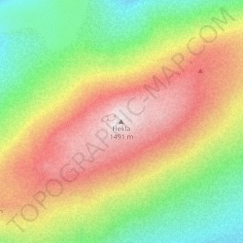
Name: Hekla topographic map, elevation, terrain.
Location: Hekla, Rangárþing ytra, Southern Region, Iceland (63.99265 -19.66587 63.99275 -19.66577)
Average elevation: 1,134 m
Minimum elevation: 824 m
Maximum elevation: 1,481 m
Make a donation
Gear up for your next adventure:
As an Amazon Associate, this site earns from qualifying purchases at no extra cost to you.
Other topographic maps
Click on a map to view its topography, its elevation and its terrain.