
Make a donation
Gear up for your next adventure:
As an Amazon Associate, this site earns from qualifying purchases at no extra cost to you.
Venkatagiri topographic map
Click on the map to display elevation.
Make a donation
Gear up for your next adventure:
As an Amazon Associate, this site earns from qualifying purchases at no extra cost to you.
Venkatagiri
Venkatagiri is located at 13°58′00″N 79°35′00″E / 13.9667°N 79.5833°E / 13.9667; 79.5833. It has an average elevation of 60 metres (197 feet).
Make a donation
Gear up for your next adventure:
As an Amazon Associate, this site earns from qualifying purchases at no extra cost to you.
About this map
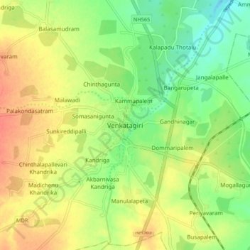
Name: Venkatagiri topographic map, elevation, terrain.
Location: Venkatagiri, Tirupati, Andhra Pradesh, 524132, India (13.91758 79.54093 13.99758 79.62093)
Average elevation: 70 m
Minimum elevation: 46 m
Maximum elevation: 93 m
Make a donation
Gear up for your next adventure:
As an Amazon Associate, this site earns from qualifying purchases at no extra cost to you.