Geolocate

Stockholm topographic map

Click on the map to display elevation.

About this map

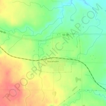
Name: Stockholm topographic map, elevation, terrain.

Location: Stockholm, Grant County, South Dakota, United States (45.09675 -96.80729 45.10688 -96.79211)

Average elevation: 503 m

Minimum elevation: 470 m

Maximum elevation: 540 m

Other topographic maps

Click on a map to view its topography, its elevation and its terrain.

Myers Lake

United States > South Dakota > Grant County

Average elevation: 582 m

Gear up for your next adventure:

🥾All-Terrain Hiking Boots - Versatile boots for varied hiking conditions
🔋Solar Power Bank - Keep your GPS and devices charged during long outdoor trips
🌡️Emergency Mylar Blankets - Compact thermal protection for unexpected nights outdoors
🧶550 Survival Paracord - Versatile utility cord for emergency repairs and rigging
🧥Ultralight Puffy Jacket - Maximum warmth that packs down to the size of an orange

As an Amazon Associate, this site earns from qualifying purchases at no extra cost to you.