
Thank you for supporting this site ❤️
Make a donation
Make a donation
Gear up for your next adventure:
As an Amazon Associate, this site earns from qualifying purchases at no extra cost to you.
Travesas topographic map
Click on the map to display elevation.
Thank you for supporting this site ❤️
Make a donation
Make a donation
Gear up for your next adventure:
As an Amazon Associate, this site earns from qualifying purchases at no extra cost to you.
About this map
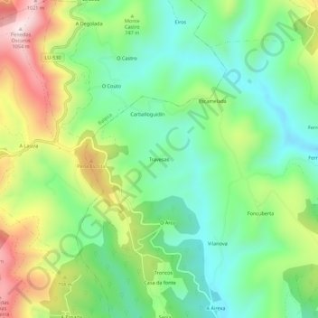
Name: Travesas topographic map, elevation, terrain.
Location: Travesas, Freixo, A Fonsagrada, Lugo, Galiza, 27134, Espanha (43.02884 -7.18086 43.06884 -7.14086)
Average elevation: 702 m
Minimum elevation: 509 m
Maximum elevation: 1,045 m
Thank you for supporting this site ❤️
Make a donation
Make a donation
Gear up for your next adventure:
As an Amazon Associate, this site earns from qualifying purchases at no extra cost to you.