Geolocate

Chavenay topographic map

Click on the map to display elevation.

About this map
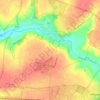
Name: Chavenay topographic map, elevation, terrain.

Location: Chavenay, Saint-Germain-en-Laye, Yvelines, Ile-de-France, Metropolitan France, 78450, France (48.83340 1.96083 48.86076 2.01140)

Average elevation: 112 m

Minimum elevation: 74 m

Maximum elevation: 134 m

Other topographic maps

Click on a map to view its topography, its elevation and its terrain.

Rodon

France > Ile-de-France > Yvelines

Average elevation: 167 m

Hautvilliers

France > Ile-de-France > Yvelines > Chevreuse

Average elevation: 127 m

La Corse

France > Ile-de-France > Yvelines > Élancourt

Average elevation: 165 m

Gear up for your next adventure:

🥾Hiking Shoes - Durable and comfortable shoes for trail hiking
🥾Lightweight Hiking Boots - Boots for comfort and mobility on long hikes
🦯Trekking Poles - Reduced impact on joints for steep topographic climbs
⛺Family Camping Tent - Spacious tent suitable for family camping trips
🩹Compact First Aid Kit - Pre-packed essentials for common trail injuries

As an Amazon Associate, this site earns from qualifying purchases at no extra cost to you.