

Sehuaya topographic map
Click on the map to display elevation.
About this map
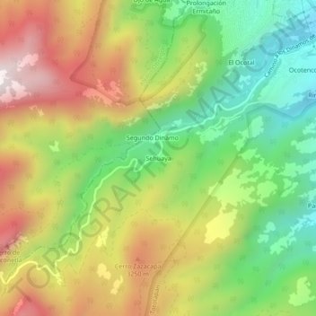
Name: Sehuaya topographic map, elevation, terrain.
Location: Sehuaya, La Magdalena Contreras, Mexico City, 10643, Mexico (19.26156 -99.29360 19.30156 -99.25360)
Average elevation: 2,973 m
Minimum elevation: 2,557 m
Maximum elevation: 3,478 m
Other topographic maps
Click on a map to view its topography, its elevation and its terrain.
Milpa Alta
It has an average altitude of 2,420 meters above sea level with altitudes varying between 2,300 and 3,600. It is part of the Trans-Mexican Volcanic Belt and the Sierra Chichinautzin volcanic mountain chain, which separates Mexico City from the state of Morelos. The borough is divided into three zones:…
Average elevation: 2,842 m
La Magdalena Contreras
La Magdalena Contreras (Spanish pronunciation: [maɣðaˈlena konˈtɾeɾas] ) is a borough (demarcación territorial) in the Mexico City. As of the 2010 census, it has a population of 239,086 inhabitants and is the third-least populous of Mexico City's boroughs. It lies at an elevation of 2,365 m (7,759 ft)…
Average elevation: 2,828 m


