Geolocate

Matiltan topographic map

Click on the map to display elevation.

About this map

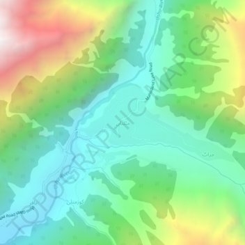
Name: Matiltan topographic map, elevation, terrain.

Location: Matiltan, Kalam Tehsil, Swat District, Malakand Division, Khyber Pakhtunkhwa, Pakistan (35.52146 72.64128 35.56146 72.68128)

Average elevation: 2,664 m

Minimum elevation: 2,084 m

Maximum elevation: 3,938 m

Other topographic maps

Click on a map to view its topography, its elevation and its terrain.

Gear up for your next adventure:

🔭Outdoor Binoculars - Lightweight binoculars for birdwatching and hiking
🎒Fully Waterproof Backpack - Total protection for photography gear and electronics
💧Collapsible Water Bottle - Space-saving water bottle for outdoor activities
🥾All-Terrain Hiking Boots - Versatile boots for varied hiking conditions
👟Sport Hiking Sandals - Breathable footwear for water crossings and camp rest

As an Amazon Associate, this site earns from qualifying purchases at no extra cost to you.