
Make a donation
Gear up for your next adventure:
As an Amazon Associate, this site earns from qualifying purchases at no extra cost to you.
Oplinter topographic map
Click on the map to display elevation.
Make a donation
Gear up for your next adventure:
As an Amazon Associate, this site earns from qualifying purchases at no extra cost to you.
Oplinter
Oplinter ligt in de Haspengouw op een hoogte van 32-72 meter. De plaats ligt aan de Grote Gete. Ten noorden van de kom ligt het Oudenbos.
Make a donation
Gear up for your next adventure:
As an Amazon Associate, this site earns from qualifying purchases at no extra cost to you.
About this map
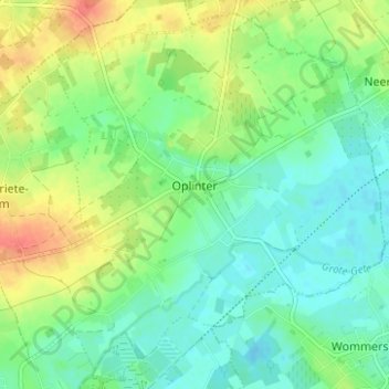
Name: Oplinter topographic map, elevation, terrain.
Location: Oplinter, Tienen, Leuven, Vlaams-Brabant, Vlaanderen, België (50.81000 4.95756 50.84676 5.01986)
Average elevation: 45 m
Minimum elevation: 28 m
Maximum elevation: 73 m
Make a donation
Gear up for your next adventure:
As an Amazon Associate, this site earns from qualifying purchases at no extra cost to you.
Other topographic maps
Click on a map to view its topography, its elevation and its terrain.
Make a donation
Gear up for your next adventure:
As an Amazon Associate, this site earns from qualifying purchases at no extra cost to you.