
Thank you for supporting this site ❤️
Make a donation
Make a donation
Gear up for your next adventure:
As an Amazon Associate, this site earns from qualifying purchases at no extra cost to you.
Sours topographic map
Click on the map to display elevation.
Thank you for supporting this site ❤️
Make a donation
Make a donation
Gear up for your next adventure:
As an Amazon Associate, this site earns from qualifying purchases at no extra cost to you.
About this map
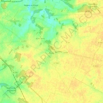
Name: Sours topographic map, elevation, terrain.
Average elevation: 151 m
Minimum elevation: 134 m
Maximum elevation: 160 m
Thank you for supporting this site ❤️
Make a donation
Make a donation
Gear up for your next adventure:
As an Amazon Associate, this site earns from qualifying purchases at no extra cost to you.
Other topographic maps
Click on a map to view its topography, its elevation and its terrain.
Le Bois Corbières
France > Centre-Val de Loire > Eure-et-Loir > Bouglainval > Le Grand Gland
Average elevation: 157 m
Maison Forestière de la Grande Noé
France > Centre-Val de Loire > Eure-et-Loir > Châteauneuf-en-Thymerais > Maison Forestière de la Grande Noé
Average elevation: 204 m