Geolocate

Murg topographic map

Click on the map to display elevation.

About this map

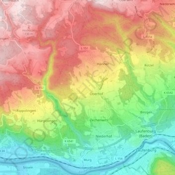
Name: Murg topographic map, elevation, terrain.

Location: Murg, Verwaltungsgemeinschaft Bad Säckingen, Landkreis Waldshut, Baden-Württemberg, 79730, Germany (47.55041 7.99404 47.62108 8.05261)

Average elevation: 520 m

Minimum elevation: 289 m

Maximum elevation: 770 m

Other topographic maps

Click on a map to view its topography, its elevation and its terrain.

Bühl

Germany > Baden-Württemberg > Landkreis Waldshut

Average elevation: 516 m

Mättle

Germany > Baden-Württemberg > Landkreis Waldshut > Todtmoos

Average elevation: 1,001 m

Gear up for your next adventure:

🧰Multitool Knife - Compact and versatile tool for outdoor use
🥾Hiking Boots - Sturdy boots providing ankle support and traction on rugged trails
🧦Hiking Liner Socks - Thin base layer to prevent friction and blisters
🥾Trekking Boots - Durable boots for long-distance trekking
💡Solar Camping Lamp - Eco-friendly lighting for campsites

As an Amazon Associate, this site earns from qualifying purchases at no extra cost to you.