Geolocate

Troncéu topographic map

Click on the map to display elevation.

About this map

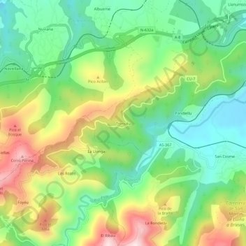
Name: Troncéu topographic map, elevation, terrain.

Location: Troncéu, Cudillero, Asturias, 33157, Spain (43.52797 -6.28514 43.56797 -6.24514)

Average elevation: 190 m

Minimum elevation: 20 m

Maximum elevation: 466 m

Gear up for your next adventure:

🛰️Satellite Messenger - Emergency communication for areas with no cell service
🎒Hiking Daypack - Lightweight and durable backpacks for day trips and excursions
🛁Quick-Dry Microfiber Towel - Space-saving towel that dries rapidly on the move
🔦LED Headtorch - Bright and durable light for night activities
🧭GPS Tracker - Track your location in remote areas safely

As an Amazon Associate, this site earns from qualifying purchases at no extra cost to you.