Geolocate

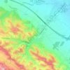
Carcassonne topographic map

Click on the map to display elevation.

About this map
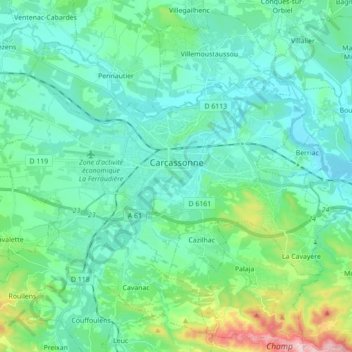
Name: Carcassonne topographic map, elevation, terrain.

Location: Carcassonne, Aude, Occitania, Metropolitan France, 11000, France (43.17131 2.26157 43.24437 2.43627)

Average elevation: 149 m

Minimum elevation: 82 m

Maximum elevation: 445 m

Other topographic maps

Click on a map to view its topography, its elevation and its terrain.
Pech d'Aspe

France > Occitania > Aude > Mas-des-Cours

Average elevation: 349 m

Cervière

France > Occitania > Aude > Armissan

Average elevation: 94 m

La Gare

France > Occitania > Aude > Villeneuve-la-Comptal

Average elevation: 220 m

La Franqui

France > Occitania > Aude > Leucate

Average elevation: 15 m

Saint-Pierre-la-Mer

France > Occitania > Aude

Average elevation: 20 m

Port-Leucate

France > Occitania > Aude > Leucate

Average elevation: 0 m

Le Castelas

France > Occitania > Aude > Rennes-le-Château

Average elevation: 381 m

Pic de Nore

France > Occitania > Aude > Pradelles-Cabardès

Average elevation: 1,063 m

Bourdials

France > Occitania > Aude > Castans

Average elevation: 745 m

Pech d'Aspe

France > Occitania > Aude > Mas-des-Cours

Average elevation: 349 m

Pech Cardou

France > Occitania > Aude > Serres

Average elevation: 427 m

Gear up for your next adventure:

🧥Ultralight Puffy Jacket - Maximum warmth that packs down to the size of an orange
🧣Merino Neck Gaiter - Protects against wind, sun, and cold at high altitudes
💡LED Headlamp - Hands-free illumination for night hiking and camping
🚲Heavy Duty Bike Lock - Secure your bike at the trailhead or during stops
💧Filtered Water Bottle - Safe drinking water on the go

As an Amazon Associate, this site earns from qualifying purchases at no extra cost to you.