Geolocate

Mount Vesuvius topographic map

Click on the map to display elevation.

Mount Vesuvius

The volcano's slopes are scarred by lava flows, while the rest are heavily vegetated, with scrub and forests at higher altitudes and vineyards lower down.

Wikipedia (CC-BY-SA 3.0)

About this map

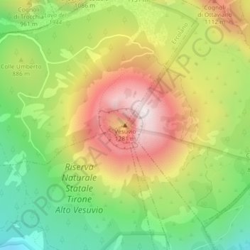
Name: Mount Vesuvius topographic map, elevation, terrain.

Location: Mount Vesuvius, Trecase, Naples, Campania, 80040, Italy (40.82135 14.42615 40.82145 14.42625)

Average elevation: 862 m

Minimum elevation: 510 m

Maximum elevation: 1,261 m

Gear up for your next adventure:

Camping Essentials - All-in-one gear for a comfortable camping trip
🛶Canoe Life Vest - Safety vest for water sports
🔪Outdoor Multitool - Versatile tool for repairs and food prep in the wild
🚲Handlebar Phone Mount - View topographic-map.com live while cycling
🧦Outdoor Socks - Durable socks designed for hiking and outdoor sports

As an Amazon Associate, this site earns from qualifying purchases at no extra cost to you.