
Make a donation
Gear up for your next adventure:
As an Amazon Associate, this site earns from qualifying purchases at no extra cost to you.
Beverly Shores topographic map
Click on the map to display elevation.
Make a donation
Gear up for your next adventure:
As an Amazon Associate, this site earns from qualifying purchases at no extra cost to you.
About this map
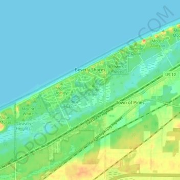
Name: Beverly Shores topographic map, elevation, terrain.
Location: Beverly Shores, Porter County, Indiana, 46301, United States (41.66232 -87.00973 41.70954 -86.93260)
Average elevation: 186 m
Minimum elevation: 175 m
Maximum elevation: 214 m
Make a donation
Gear up for your next adventure:
As an Amazon Associate, this site earns from qualifying purchases at no extra cost to you.
Other topographic maps
Click on a map to view its topography, its elevation and its terrain.
Indiana Dunes State Park
United States > Indiana > Porter County > Chesterton
Average elevation: 186 m
Beverly Shores
United States > Indiana > Porter County > Beverly Shores > Beverly Shores
Average elevation: 182 m