
Make a donation
Gear up for your next adventure:
As an Amazon Associate, this site earns from qualifying purchases at no extra cost to you.
Lippramsdorf topographic map
Click on the map to display elevation.
Make a donation
Gear up for your next adventure:
As an Amazon Associate, this site earns from qualifying purchases at no extra cost to you.
About this map
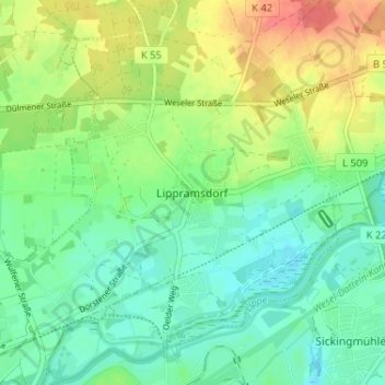
Name: Lippramsdorf topographic map, elevation, terrain.
Average elevation: 47 m
Minimum elevation: 25 m
Maximum elevation: 86 m
Make a donation
Gear up for your next adventure:
As an Amazon Associate, this site earns from qualifying purchases at no extra cost to you.
Other topographic maps
Click on a map to view its topography, its elevation and its terrain.
Lavesum
Deutschland > Nordrhein-Westfalen > Kreis Recklinghausen > Haltern am See
Average elevation: 74 m
Halterner Stausee
Deutschland > Nordrhein-Westfalen > Kreis Recklinghausen > Haltern am See
Average elevation: 47 m
Overrath
Deutschland > Nordrhein-Westfalen > Kreis Recklinghausen > Haltern am See
Average elevation: 45 m