
Thank you for supporting this site ❤️
Make a donation
Make a donation
Gear up for your next adventure:
As an Amazon Associate, this site earns from qualifying purchases at no extra cost to you.
Krottenkopf topographic map
Click on the map to display elevation.
Thank you for supporting this site ❤️
Make a donation
Make a donation
Gear up for your next adventure:
As an Amazon Associate, this site earns from qualifying purchases at no extra cost to you.
About this map
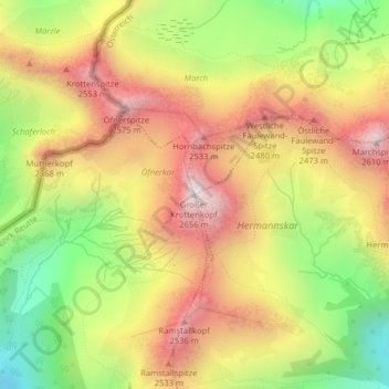
Name: Krottenkopf topographic map, elevation, terrain.
Location: Krottenkopf, Holzgau, Bezirk Reutte, Tirol, Österreich (47.31150 10.35561 47.31160 10.35571)
Average elevation: 2,158 m
Minimum elevation: 1,639 m
Maximum elevation: 2,627 m
Thank you for supporting this site ❤️
Make a donation
Make a donation
Gear up for your next adventure:
As an Amazon Associate, this site earns from qualifying purchases at no extra cost to you.