Geolocate

Seignosse topographic map

Click on the map to display elevation.

About this map
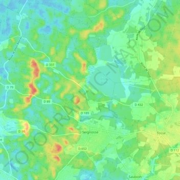
Name: Seignosse topographic map, elevation, terrain.

Location: Seignosse, District of Dax, Landes, Nouvelle-Aquitaine, Metropolitan France, 40510, France (43.66939 -1.44159 43.74166 -1.34620)

Average elevation: 19 m

Minimum elevation: 2 m

Maximum elevation: 54 m

Other topographic maps

Click on a map to view its topography, its elevation and its terrain.

Lassale

France > Nouvelle-Aquitaine > Landes > Castandet

Average elevation: 95 m

Jay

France > Nouvelle-Aquitaine > Landes > Sarbazan

Average elevation: 93 m

Sanguina

France > Nouvelle-Aquitaine > Landes > Luglon

Average elevation: 89 m

ME ?

France > Nouvelle-Aquitaine > Landes > Saint-Pierre-du-Mont

Average elevation: 90 m

Chit

France > Nouvelle-Aquitaine > Landes > Payros-Cazautets

Average elevation: 129 m

Bélida

France > Nouvelle-Aquitaine > Landes > Meilhan

Average elevation: 74 m

Milord

France > Nouvelle-Aquitaine > Landes > Mugron

Average elevation: 65 m

Le Conte

France > Nouvelle-Aquitaine > Landes > Geaune > Pichots

Average elevation: 134 m

Huron

France > Nouvelle-Aquitaine > Landes > Geaune

Average elevation: 157 m

Pabon

France > Nouvelle-Aquitaine > Landes > Garein

Average elevation: 95 m

Molin Nau

France > Nouvelle-Aquitaine > Landes > Mimizan

Average elevation: 20 m

Gear up for your next adventure:

🧭GPS Tracker - Track your location in remote areas safely
🎒Hiking Backpack - Lightweight and ergonomic backpacks for day hikes or multi-day treks
💡LED Camping Lantern - Illuminate your campsite with long-lasting lanterns
🧤Rechargeable Heated Gloves - Extreme warmth for Canadian winter expeditions
🪜Heavy Duty Carabiners - Multi-use clips for securing gear to your backpack

As an Amazon Associate, this site earns from qualifying purchases at no extra cost to you.