Geolocate

Ciparay topographic map

Click on the map to display elevation.

About this map

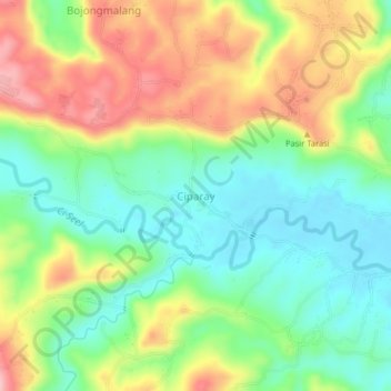
Name: Ciparay topographic map, elevation, terrain.

Location: Ciparay, Ciamis, West Java, Java, Indonesia (-7.44295 108.45183 -7.40295 108.49183)

Average elevation: 99 m

Minimum elevation: 31 m

Maximum elevation: 196 m

Other topographic maps

Click on a map to view its topography, its elevation and its terrain.

Ciamis

Indonesia > West Java > Ciamis

Ciamis Regency consists of 328 villages, with the topography predominantly characterized by 153 villages in the plains, 162 villages on the slopes, and 13 villages in the Watershed (DAS) area.

Average elevation: 217 m

Linggasari

Indonesia > West Java > Ciamis > Ciamis

Average elevation: 218 m

Bojongmengger

Indonesia > West Java > Ciamis

Average elevation: 118 m

Cikoneng

Indonesia > West Java > Ciamis

Average elevation: 492 m

Gear up for your next adventure:

🧥Fleece Jacket - Warm and lightweight jacket for layering
🧥Waterproof Pants - Keep dry during rainy hiking conditions
💡LED Camping Lantern - Illuminate your campsite with long-lasting lanterns
🧦Outdoor Socks - Durable socks designed for hiking and outdoor sports
🕯️Camping Lantern - Illuminates your entire campsite with high-efficiency LEDs

As an Amazon Associate, this site earns from qualifying purchases at no extra cost to you.