
Thank you for supporting this site ❤️
Make a donation
Make a donation
Gear up for your next adventure:
As an Amazon Associate, this site earns from qualifying purchases at no extra cost to you.
Winklern topographic map
Click on the map to display elevation.
Thank you for supporting this site ❤️
Make a donation
Make a donation
Gear up for your next adventure:
As an Amazon Associate, this site earns from qualifying purchases at no extra cost to you.
Winklern
Der Erwerbsstatus ist in Winklern ähnlich dem der Nachbargemeinden. Der Standort des Pflege- und Pensionistenheimes spiegelt sich im etwas höheren Pensionistenanteil (Daten von 2011).
Thank you for supporting this site ❤️
Make a donation
Make a donation
Gear up for your next adventure:
As an Amazon Associate, this site earns from qualifying purchases at no extra cost to you.
About this map
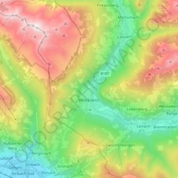
Name: Winklern topographic map, elevation, terrain.
Average elevation: 1,537 m
Minimum elevation: 650 m
Maximum elevation: 2,862 m
Thank you for supporting this site ❤️
Make a donation
Make a donation
Gear up for your next adventure:
As an Amazon Associate, this site earns from qualifying purchases at no extra cost to you.