Geolocate

Aplaya topographic map

Click on the map to display elevation.

About this map

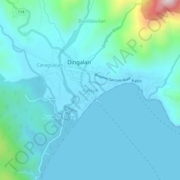
Name: Aplaya topographic map, elevation, terrain.

Location: Aplaya, Dingalan, Aurora, Central Luzon, Philippines (15.36318 121.37523 15.40318 121.41523)

Average elevation: 80 m

Minimum elevation: 0 m

Maximum elevation: 655 m

Other topographic maps

Click on a map to view its topography, its elevation and its terrain.

Umiray River

Philippines > Aurora > Dingalan > Abungan

Average elevation: 93 m

Dingalan River

Philippines > Aurora > Dingalan

Average elevation: 188 m

Gear up for your next adventure:

🔦LED Flashlight - Powerful and long-lasting flashlight for camping and emergencies
🧥Packable Rain Jacket - Breathable waterproof layer for unpredictable weather
🧰Survival Kit - Essential gear for emergencies in the wilderness
🌬️Windproof Camp Stove - Efficient cooking even on exposed mountain peaks
🧦Crew Hiking Socks - Comfortable socks for long-distance hikes

As an Amazon Associate, this site earns from qualifying purchases at no extra cost to you.