
Make a donation
Gear up for your next adventure:
As an Amazon Associate, this site earns from qualifying purchases at no extra cost to you.
Kirtland topographic map
Click on the map to display elevation.
Make a donation
Gear up for your next adventure:
As an Amazon Associate, this site earns from qualifying purchases at no extra cost to you.
Kirtland
Kirtland is located south of the lake shore plain of Lake Erie and is situated on the higher elevations of the Allegheny Plateau. The principal geographic features are the East Branch of the Chagrin River, Pierson's Knob, and Gildersleeve Mountain, 1,163 feet (354 m) Daniel's Mountain,1,246 feet (380 m) is the high point.
Make a donation
Gear up for your next adventure:
As an Amazon Associate, this site earns from qualifying purchases at no extra cost to you.
About this map
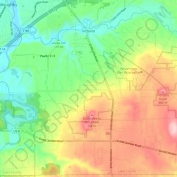
Name: Kirtland topographic map, elevation, terrain.
Location: Kirtland, Lake County, Ohio, United States (41.56974 -81.39209 41.64081 -81.29499)
Average elevation: 266 m
Minimum elevation: 183 m
Maximum elevation: 382 m
Make a donation
Gear up for your next adventure:
As an Amazon Associate, this site earns from qualifying purchases at no extra cost to you.
Other topographic maps
Click on a map to view its topography, its elevation and its terrain.