
Make a donation
Gear up for your next adventure:
As an Amazon Associate, this site earns from qualifying purchases at no extra cost to you.
Nice topographic map
Click on the map to display elevation.
Make a donation
Gear up for your next adventure:
As an Amazon Associate, this site earns from qualifying purchases at no extra cost to you.
Nice
Nice is a census-designated place (CDP) in Lake County, California, United States. Nice is located 4.5 miles (7.2 km) southeast of Upper Lake, at an elevation of 1362 feet (415 m). The population was 2,731 at the 2010 census, up from 2,509 at the 2000 census.
Make a donation
Gear up for your next adventure:
As an Amazon Associate, this site earns from qualifying purchases at no extra cost to you.
About this map
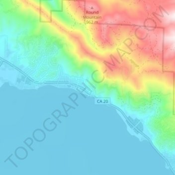
Name: Nice topographic map, elevation, terrain.
Location: Nice, Lake County, California, 95464, United States (39.10390 -122.88571 39.13866 -122.81268)
Average elevation: 561 m
Minimum elevation: 402 m
Maximum elevation: 1,026 m
Make a donation
Gear up for your next adventure:
As an Amazon Associate, this site earns from qualifying purchases at no extra cost to you.
Other topographic maps
Click on a map to view its topography, its elevation and its terrain.
San Francisco
San Francisco is characterized by its striking and varied topography, making it one of the most distinctive cities in the United States. The landscape features a mix of rolling hills and steep inclines, with the highest elevation reaching approximately 922 feet at Twin Peaks. The average elevation across the…
Average elevation: 65 m
San Diego
United States > California > San Diego County
San Diego is characterized by a diverse topography that features coastal plains, rolling hills, and rugged mountain ranges. The city is situated along the Pacific Ocean, where it boasts an extensive shoreline with sandy beaches and tidal zones. As you move inland, the landscape transitions from the flat…
Average elevation: 125 m
Los Angeles
United States > California > Los Angeles County
Los Angeles is characterized by a diverse and dynamic topography. The city is predominantly situated in a basin bordered by mountain ranges, including the Santa Monica Mountains to the north and the San Gabriel Mountains to the east, with elevations reaching up to about 10,000 feet (3,048 meters) in certain…
Average elevation: 241 m
San Francisco Bay Area
United States > California > San Francisco
The San Francisco Bay Area is characterized by a diverse and dynamic topography shaped by geological processes over millions of years. This region features a combination of coastal plains, steep hills, and rugged mountains, all influenced by the tectonic activity associated with the nearby San Andreas Fault…
Average elevation: 113 m
Make a donation
Gear up for your next adventure:
As an Amazon Associate, this site earns from qualifying purchases at no extra cost to you.
San Jose
United States > California > Santa Clara County
San Jose, located in Santa Clara County, California, features a diverse topography characterized by a mix of low-lying plains and rolling hills. The city sits at an average elevation of approximately 82 feet (25 meters) above sea level, with the surrounding terrain including the foothills of the Santa Cruz…
Average elevation: 265 m
Los Angeles
United States > California > Los Angeles County
Los Angeles is characterized by a diverse and dynamic topography. The city is predominantly situated in a basin bordered by mountain ranges, including the Santa Monica Mountains to the north and the San Gabriel Mountains to the east, with elevations reaching up to about 10,000 feet (3,048 meters) in certain…
Average elevation: 241 m
Santa Clara County
Santa Clara County features a diverse and varied topography characterized by both low-lying valleys and rugged mountainous regions. The county encompasses a significant portion of Silicon Valley, where flat, urbanized areas are interspersed with rolling hills and foothills that rise sharply in the Santa Cruz…
Average elevation: 323 m
Lake Tahoe
United States > California > Placer County
Lake Tahoe is renowned for its dramatic topography, characterized by rugged mountain ranges and deep, crystal-clear waters. Nestled in the Sierra Nevada, the lake itself lies at an elevation of approximately 6,225 feet (1,897 meters) and spans about 22 miles (35 kilometers) in length and 12 miles (19…
Average elevation: 2,077 m
Make a donation
Gear up for your next adventure:
As an Amazon Associate, this site earns from qualifying purchases at no extra cost to you.
Roseville
United States > California > Placer County
Roseville has a hot-summer Mediterranean climate that is characterized by cool, wet, usually snowless winters and hot, dry summers (Köppen Csa). The wet season is generally October through April. Because Roseville is east of Sacramento and at a higher elevation, it receives slightly more rainfall. Average…
Average elevation: 67 m
Oakland
United States > California > Alameda County
Oakland features a diverse topography shaped by its location along the eastern shore of San Francisco Bay and the presence of the nearby coastal hills. The city sits on a flat coastal plain that gradually ascends toward the Oakland Hills to the east, where elevations can exceed 1,700 feet. The highest point…
Average elevation: 51 m
Newport Beach
United States > California > Orange County
Newport Beach, located in Orange County, California, features a dynamic and varied topography shaped by its coastal position and surrounding hills. The city spans from sea level along its beaches to elevations of over 1,100 feet (335 meters) in the nearby San Joaquin Hills. These hills, particularly noticeable…
Average elevation: 14 m
Make a donation
Gear up for your next adventure:
As an Amazon Associate, this site earns from qualifying purchases at no extra cost to you.
Yosemite National Park
The geology of the Yosemite area is characterized by granite rocks and remnants of older rock. About 10 million years ago, the Sierra Nevada was uplifted and tilted to form its unique slopes, which increased the steepness of stream and river beds, resulting in the formation of deep, narrow canyons. About one…
Average elevation: 2,337 m
Ramona
United States > California > San Diego County
In January 2006, Ramona Valley was designated the country's 162nd American Viticultural Area (AVA) by the Alcohol and Tobacco Tax and Trade Bureau, which recognized the area for its distinctive microclimate, elevation, and soil attributes.
Average elevation: 469 m
Berkeley
United States > California > Alameda County
Berkeley, located on the eastern shore of San Francisco Bay, features a diverse topography characterized by rolling hills and steep slopes. The city sits at an elevation that ranges from sea level along the bay to about 1,300 feet (396 meters) in the Berkeley Hills. This hilly landscape provides stunning views…
Average elevation: 109 m
Make a donation
Gear up for your next adventure:
As an Amazon Associate, this site earns from qualifying purchases at no extra cost to you.
Pasadena
United States > California > Los Angeles County
An obscure portion of the Angeles Crest Highway (SR 2) in the San Gabriel Mountains cuts through Pasadena near the Angeles Crest Ranger Station. This 2-mile (3.2 km) stretch of highway in the Angeles National Forest is north of La Cañada Flintridge and west of Mount Wilson and is approximately 3,000 feet (910…
Average elevation: 548 m
Make a donation
Gear up for your next adventure:
As an Amazon Associate, this site earns from qualifying purchases at no extra cost to you.
Yosemite National Park
The geology of the Yosemite area is characterized by granite rocks and remnants of older rock. About 10 million years ago, the Sierra Nevada was uplifted and tilted to form its unique slopes, which increased the steepness of stream and river beds, resulting in the formation of deep, narrow canyons. About one…
Average elevation: 2,337 m
La Quinta
United States > California > Riverside County
La Quinta is located at 33°40′31″N 116°17′51″W / 33.67528°N 116.29750°W / 33.67528; -116.29750 (33.675373, −116.297391). According to the United States Census Bureau, the city has a total area of 35.6 square miles (92 km2), of which 35.1 square miles (91 km2) is land and 0.4 square miles…
Average elevation: 201 m
Miraleste
United States > California > Los Angeles County > Rancho Palos Verdes
Average elevation: 201 m
Make a donation
Gear up for your next adventure:
As an Amazon Associate, this site earns from qualifying purchases at no extra cost to you.
Joshua Tree National Park
Joshua Tree National Park is an American national park in southeastern California, east of San Bernardino and Los Angeles and north of Palm Springs. It is named after the Joshua trees (Yucca brevifolia) native to the Mojave Desert. Originally declared a national monument in 1936, Joshua Tree was redesignated…
Average elevation: 639 m
San Fernando Valley
United States > California > Los Angeles County > Los Angeles
Average elevation: 496 m
Make a donation
Gear up for your next adventure:
As an Amazon Associate, this site earns from qualifying purchases at no extra cost to you.
Santa Clarita
United States > California > Los Angeles County
The official elevation of the city is 1,207 feet (368 m), the elevation of the historic Newhall Airport which was northwest of Via Princessa and Railroad Avenue from the 1930s through the 1950s. Elevation varies substantially throughout the city. The lowest point in Santa Clarita is near the junction of CA-126…
Average elevation: 514 m
Long Beach
United States > California > Los Angeles County
Willow Springs Park was founded as a part of the Willow Springs Wetlands Restoration Project which opened in October 2017. The project restored 11 acres of a 48-acre degraded oil well site into wetlands. These highlight the pivotal role the ecosystem played in the City of Long Beach’s establishment in the…
Average elevation: 12 m
Redding
United States > California > Shasta County
The elevation in Redding is 495 feet (151 meters) on average, whereas anywhere to the north, east, or west of downtown ranges between 550 feet (170 m) and 800 feet (240 m) feet. Southern portions range between 400 feet (120 m) and 500 feet (150 m).
Average elevation: 240 m
Make a donation
Gear up for your next adventure:
As an Amazon Associate, this site earns from qualifying purchases at no extra cost to you.
Los Angeles County
Los Angeles County's topography is characterized by a diverse landscape that includes coastal plains, mountain ranges, and expansive valleys. The county is situated within the Los Angeles Basin, a large sedimentary basin bounded by the Santa Monica Mountains to the north and the San Gabriel Mountains to the…
Average elevation: 378 m
Joshua Tree National Park
Joshua Tree National Park is an American national park in southeastern California, east of San Bernardino and Los Angeles and north of Palm Springs. It is named after the Joshua trees (Yucca brevifolia) native to the Mojave Desert. Originally declared a national monument in 1936, Joshua Tree was redesignated…
Average elevation: 639 m
Make a donation
Gear up for your next adventure:
As an Amazon Associate, this site earns from qualifying purchases at no extra cost to you.
Camarillo
United States > California > Ventura County
In the mid-1950s, the Ventura Freeway was completed from Los Angeles to points north, making it an easy one-hour trip to Camarillo. The Old Town was bisect by the Ventura Freeway. On the southern side of the freeway contains a strip of businesses, churches, schools, and parks. The freeway was originally…
Average elevation: 90 m
San Diego County
San Diego County's topography is marked by its dramatic variety, ranging from coastal plains to mountainous regions. The county stretches along California's southern border, with a coastline that includes sandy beaches, cliffs, and bays, such as the iconic San Diego Bay. Inland, the terrain rises into the…
Average elevation: 544 m
Sequoia National Park
United States > California > Tulare County
Many park visitors enter Sequoia National Park through its southern entrance near the town of Three Rivers at Ash Mountain at 1,700 ft (520 m) elevation. The lower elevations around Ash Mountain contain the only National Park Service-protected California Foothills ecosystem, consisting of blue oak woodlands,…
Average elevation: 2,515 m
Make a donation
Gear up for your next adventure:
As an Amazon Associate, this site earns from qualifying purchases at no extra cost to you.
El Cerrito
United States > California > Contra Costa County
According to the United States Census Bureau, the city has a total area of 3.7 square miles (9.6 km2), all of it land. The city ranges in elevation from 20 to 934 feet, with an average elevation of 69 feet (21 m).
Average elevation: 91 m
South Lake Tahoe
United States > California > El Dorado County
According to the United States Census Bureau, the city has a total area of 16.6 square miles (43 km2), of which 10.2 square miles (26 km2) is land and 6.4 square miles (17 km2), or 38.80%, is water. Its elevation is about 6,237 feet (1,901 m) above sea level.
Average elevation: 1,979 m
Make a donation
Gear up for your next adventure:
As an Amazon Associate, this site earns from qualifying purchases at no extra cost to you.
Sonoma County
Sonoma County, as is often the case with coastal counties in California, has a great degree of climatic variation and numerous, often very different, microclimates. Key determining factors for local climate are proximity to the ocean, elevation, and the presence and elevation of hills or mountains to the east…
Average elevation: 210 m
Napa County
Napa is warmer in the summer than Sonoma County, to the west, or Santa Barbara County, a wine-producing county in southern California. Thus, the Napa wineries favor varietals such as Cabernet Sauvignon, while Pinot noir and Chardonnay are more the specialty of Sonoma and Santa Barbara wineries. At the north…
Average elevation: 232 m
Sacramento County
According to the U.S. Census Bureau, the county has a total area of 994 square miles (2,570 km2), of which 965 square miles (2,500 km2) is land and 29 square miles (75 km2) (3.0%) is water. Most of the county is at an elevation close to sea level, with some areas below sea level. The highest point in the…
Average elevation: 62 m
Make a donation
Gear up for your next adventure:
As an Amazon Associate, this site earns from qualifying purchases at no extra cost to you.
Amador County
Amador County ranges in elevation from approximately 250 feet (76 m) in the western portion of the county to over 9,000 feet (2,700 m) in the eastern portion of the county, the tallest point being Thunder Mountain. The county is bordered on the north by the Cosumnes River and El Dorado County and on the south…
Average elevation: 896 m
Make a donation
Gear up for your next adventure:
As an Amazon Associate, this site earns from qualifying purchases at no extra cost to you.
Oceanside
United States > California > San Diego County
Oceanside features a diverse topography characterized by its coastal setting and gentle inland elevations. The city is predominantly flat, with its elevation averaging around 66 feet (20 meters) above sea level, allowing for expansive views of the Pacific Ocean along its roughly 3.5 miles of coastline. Inland,…
Average elevation: 32 m
Banning
United States > California > Riverside County
Banning's elevation is approximately 2,300 feet (700 m) above sea level, which gives it a cooler climate in contrast to the county seat of Riverside at 800 feet (240 m) above sea level and the Coachella Valley of the Colorado Desert to the east.
Average elevation: 1,036 m
Make a donation
Gear up for your next adventure:
As an Amazon Associate, this site earns from qualifying purchases at no extra cost to you.
Porterville
United States > California > Tulare County
Porterville, lying along the foothills of the Sierras at an elevation of 455 feet (139 m), is located on State Highway 65, 165 miles (266 km) north of Los Angeles, and 171 miles (275 km) east of the Pacific Coast. The city has a strategic central location to major markets and a ready access to major…
Average elevation: 175 m
Death Valley National Park
There are two major valleys in the park, Death Valley and Panamint Valley. Both of these valleys were formed within the last few million years and both are bounded by north–south-trending mountain ranges. These and adjacent valleys follow the general trend of Basin and Range topography with one modification:…
Average elevation: 1,171 m
Imperial County
Fort Yuma is located on the banks of the Colorado River in Winterhaven, California. First established after the end of the Mexican–American War in 1848, it was originally located in the bottoms near the Colorado River, less than 1 mile (1.6 km) below the mouth of the Gila River. It was to defend the newly…
Average elevation: 190 m
Make a donation
Gear up for your next adventure:
As an Amazon Associate, this site earns from qualifying purchases at no extra cost to you.
Cajon Pass
United States > California > San Bernardino County
Cajon Pass (/kəˈhoʊn/; Spanish: Puerto del Cajón or Paso del Cajón) is a mountain pass between the San Bernardino Mountains to the east and the San Gabriel Mountains to the west in Southern California. Created by the movements of the San Andreas Fault, it has an elevation of 3,777 ft (1,151 m). Located in…
Average elevation: 1,169 m
Make a donation
Gear up for your next adventure:
As an Amazon Associate, this site earns from qualifying purchases at no extra cost to you.
Palm Springs
United States > California > Riverside County
One possible origin of palm in the place name comes from early Spanish explorers who referred to the area as La Palma de la Mano de Dios or "The Palm of God's hand". The earliest use of the name "Palm Springs" is from United States Topographical Engineers who used the term in 1853 maps. According to William…
Average elevation: 859 m
Make a donation
Gear up for your next adventure:
As an Amazon Associate, this site earns from qualifying purchases at no extra cost to you.
Grand Terrace
United States > California > San Bernardino County
This 3.6-square-mile (9.3 km2) community has an average elevation of 1,065 feet (325 m). Its motto, inscribed on the city flag, is "The Blue Mountain City" (its official slogan is "A city set upon a mountain cannot be hidden"), and refers to the Blue Lupine flower that used to grow on Blue Mountain in the…
Average elevation: 343 m
Make a donation
Gear up for your next adventure:
As an Amazon Associate, this site earns from qualifying purchases at no extra cost to you.
Bakersfield
United States > California > Kern County
Most of Bakersfield's major streets are six-lane divided roads with bike lanes, with almost every street in the city having proper lane signage for bicycle traffic. Bikes are a popular method of transportation in Bakersfield, due to the city's relatively flat topography and grid-like street system. Newer…
Average elevation: 157 m
Victorville
United States > California > San Bernardino County
Victorville is bordered by Apple Valley on the east, Hesperia on the south, and Adelanto on the west. The Mojave River flows sporadically through Victorville. The elevation at City Hall is approximately 2,950 feet (900 m) above sea level.
Average elevation: 920 m
Monterey
United States > California > Monterey County
During winter, snow occasionally falls in the higher elevations of the Santa Lucia Mountains and Gabilan Mountains that overlook Monterey, but snow in Monterey itself is extremely rare. A few unusual events in January 1962, February 1976, and December 1997 brought a light coating of snow to Monterey. In March…
Average elevation: 50 m
Make a donation
Gear up for your next adventure:
As an Amazon Associate, this site earns from qualifying purchases at no extra cost to you.
San Joaquin County
According to the U.S. Census Bureau, the county has a total area of 1,426 square miles (3,690 km2), of which 1,391 square miles (3,600 km2) is land and 35 square miles (91 km2), comprising 2.5%, is water. The county has a very low inland elevation and a very flat drainage basin for the San Joaquin River and…
Average elevation: 96 m
Tehachapi
United States > California > Kern County
Tehachapi (/təˈhætʃəpi/ (listen); Kawaiisu: Tihachipia, meaning "hard climb") is a city in Kern County, California, United States, in the Tehachapi Mountains, at an elevation of 3,970 feet (1,210 m), between the San Joaquin Valley and the Mojave Desert. Tehachapi is 35 miles (56 km) east-southeast of…
Average elevation: 1,414 m
Make a donation
Gear up for your next adventure:
As an Amazon Associate, this site earns from qualifying purchases at no extra cost to you.
Lone Pine
United States > California > Inyo County
Lone Pine is a census-designated place (CDP) in Inyo County, California, United States. Lone Pine is located 16 mi (26 km) south-southeast of Independence, at an elevation of 3,727 ft (1,136 m). The population was 2,035 at the 2010 census, up from 1,655 at the 2000 census. The town is located in the Owens…
Average elevation: 1,298 m
Bodie
United States > California > Mono County
Bodie (/ˈboʊdiː/ BOH-dee) is a ghost town in the Bodie Hills east of the Sierra Nevada mountain range in Mono County, California, United States. It is about 75 miles (121 km) southeast of Lake Tahoe, and 12 mi (19 km) east-southeast of Bridgeport, at an elevation of 8,379 feet (2554 m). Bodie became a boom…
Average elevation: 2,627 m
Santa Barbara
United States > California > Santa Barbara County
Annual rainfall totals are highly variable and in exceptional years like 1940–1941 and 1997–1998 over 40 inches (1.0 m) of rain have fallen in a year, but in dry seasons less than 6 inches (150 mm) is not unheard of. Snow sometimes covers higher elevations of the Santa Ynez Mountains but is extremely rare…
Average elevation: 119 m
Make a donation
Gear up for your next adventure:
As an Amazon Associate, this site earns from qualifying purchases at no extra cost to you.
Lake Arrowhead
United States > California > San Bernardino County > Twin Peaks
Average elevation: 1,563 m
Make a donation
Gear up for your next adventure:
As an Amazon Associate, this site earns from qualifying purchases at no extra cost to you.
Salinas
United States > California > Monterey County
Prior to mass agricultural and urban development, much of the city consisted of rolling hills bisected by wooded creeks and interspersed with marsh land. Today, the city is located mostly on leveled ground, with some rolling hills and wooded gulches with creeks remaining in the north-eastern Creekbridge and…
Average elevation: 19 m
Make a donation
Gear up for your next adventure:
As an Amazon Associate, this site earns from qualifying purchases at no extra cost to you.
Whittier
United States > California > Los Angeles County
Whittier is about 15 miles (24 km) inland of the Pacific Ocean, resulting in higher daytime temperatures, and since it lies at a higher elevation than the cities further west, cold air drains into the lower elevation of the Los Angeles Basin which results in warmer night-time lows, producing an example of…
Average elevation: 115 m
Escondido
United States > California > San Diego County
Escondido has a borderline semi-arid climate (Köppen: Bsh) and hot-summer Mediterranean climate (Köppen: Csa) with hot summers and cool wet winters. Owing to its inland setting it is considerably warmer than coastal cities like San Diego, Carlsbad or Oceanside during the summertime, and cooler in the winter.…
Average elevation: 273 m
Encinitas
United States > California > San Diego County
Encinitas lies on rugged coastal terrace. The city is bisected by a low-lying coastal ridge that separates New and Old Encinitas. In the north of the city, the coast rises in elevation and the land is raised up in the form of many coastal bluffs. These cliffs are subject to collapsing on the narrow beach. The…
Average elevation: 32 m
San Ramon
United States > California > Contra Costa County
The topography of San Ramon is varied, featuring a mix of the rolling hills of the Diablo Range and the flatter basin of the San Ramon Valley. The city is predominantly urban and residential with many new housing developments; however, much of the land around the city's perimeter regions remains undeveloped,…
Average elevation: 210 m
Make a donation
Gear up for your next adventure:
As an Amazon Associate, this site earns from qualifying purchases at no extra cost to you.
Palm Springs
United States > California > Riverside County
One possible origin of palm in the place name comes from early Spanish explorers who referred to the area as La Palma de la Mano de Dios or "The Palm of God's hand". The earliest use of the name "Palm Springs" is from United States Topographical Engineers who used the term in 1853 maps. According to William…
Average elevation: 859 m
Folsom
United States > California > Sacramento County
Carpenter Hill in Folsom has the highest elevation in Sacramento County.
Average elevation: 90 m
Make a donation
Gear up for your next adventure:
As an Amazon Associate, this site earns from qualifying purchases at no extra cost to you.