Geolocate

Sawang topographic map

Click on the map to display elevation.

About this map

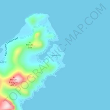
Name: Sawang topographic map, elevation, terrain.

Location: Sawang, Zamboanga del Norte, Zamboanga Peninsula, Philippines (8.66614 123.48406 8.70614 123.52406)

Average elevation: 32 m

Minimum elevation: 0 m

Maximum elevation: 364 m

Other topographic maps

Click on a map to view its topography, its elevation and its terrain.

Sibuco

Philippines > Zamboanga del Norte

Average elevation: 177 m

Dapitan River

Philippines > Zamboanga del Norte

Average elevation: 293 m

Sibuco

Philippines > Zamboanga del Norte

Average elevation: 177 m

Gear up for your next adventure:

🥾Hiking Boots - Sturdy boots providing ankle support and traction on rugged trails
Camping Tent - Weather-resistant tents suitable for 2 to 6 people
🪑Ultralight Camping Stool - Compact seating for rest stops during long hikes
🥾All-Terrain Hiking Boots - Versatile boots for varied hiking conditions
🧤Rechargeable Heated Gloves - Extreme warmth for Canadian winter expeditions

As an Amazon Associate, this site earns from qualifying purchases at no extra cost to you.