
Make a donation
Gear up for your next adventure:
As an Amazon Associate, this site earns from qualifying purchases at no extra cost to you.
Kahlenberg topographic map
Click on the map to display elevation.
Make a donation
Gear up for your next adventure:
As an Amazon Associate, this site earns from qualifying purchases at no extra cost to you.
Kahlenberg
Der Ortsteil mit 360 Einwohnern liegt auf einer Höhe von etwa 250 bis 270 Metern und erstreckt sich als Waldhufensiedlung am rechten Ufer der Hörsel über eine Länge von etwa 2,7 Kilometer.
Make a donation
Gear up for your next adventure:
As an Amazon Associate, this site earns from qualifying purchases at no extra cost to you.
About this map
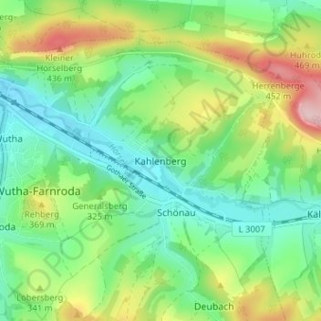
Name: Kahlenberg topographic map, elevation, terrain.
Average elevation: 314 m
Minimum elevation: 237 m
Maximum elevation: 469 m
Make a donation
Gear up for your next adventure:
As an Amazon Associate, this site earns from qualifying purchases at no extra cost to you.
Other topographic maps
Click on a map to view its topography, its elevation and its terrain.