Geolocate

Mount Kitanglad topographic map

Click on the map to display elevation.

Mount Kitanglad

Due to its high elevation, several communications and broadcasting companies constructed relay stations at the summit.

Wikipedia (CC-BY-SA 3.0)

About this map

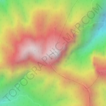
Name: Mount Kitanglad topographic map, elevation, terrain.

Location: Mount Kitanglad, Impasugong, Bukidnon, Northern Mindanao, 8702, Philippines (8.13961 124.91603 8.13971 124.91613)

Average elevation: 2,393 m

Minimum elevation: 1,789 m

Maximum elevation: 2,850 m

Gear up for your next adventure:

🧤Insulated Winter Gloves - Heavy-duty protection for sub-zero Canadian adventures
🥾All-Terrain Hiking Boots - Versatile boots for varied hiking conditions
🥾Lightweight Hiking Shoes - Comfortable shoes for day hikes
🌡️Emergency Mylar Blankets - Compact thermal protection for unexpected nights outdoors
💡Compact LED Flashlight - Powerful and portable flashlight for outdoor use

As an Amazon Associate, this site earns from qualifying purchases at no extra cost to you.