
Make a donation
Gear up for your next adventure:
As an Amazon Associate, this site earns from qualifying purchases at no extra cost to you.
Fuhlen topographic map
Click on the map to display elevation.
Make a donation
Gear up for your next adventure:
As an Amazon Associate, this site earns from qualifying purchases at no extra cost to you.
Fuhlen
Fuhlen hat heute rund 800 Einwohner. Die Landwirtschaft spielt in Fuhlen als Lebensgrundlage kaum noch eine Rolle. Es gibt verschiedene kleine ortsansässige Unternehmen. Der Großteil arbeitet außerhalb. 1995 wurde die Siedlung „Dornenpark“ gebaut, um das Dorfbild zwischen Brüggenanger und Kerndorf zu schließen. Nach dem Bau der Umgehungsstraße wird die Ortsdurchfahrt Fuhlen zurückgebaut und erneuert. Im Zuge der Dorferneuerung wurde 2007 der „Dieter-Grabbe-Platz“ mit einem Dorfbrunnen errichtet. Jährlicher Höhepunkt ist die seit der Reformation abgehaltene Kirmes, die stets im August stattfindet.
Make a donation
Gear up for your next adventure:
As an Amazon Associate, this site earns from qualifying purchases at no extra cost to you.
About this map
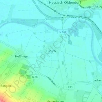
Name: Fuhlen topographic map, elevation, terrain.
Average elevation: 70 m
Minimum elevation: 56 m
Maximum elevation: 150 m
Make a donation
Gear up for your next adventure:
As an Amazon Associate, this site earns from qualifying purchases at no extra cost to you.