Geolocate

Sanitarium topographic map

Click on the map to display elevation.

About this map

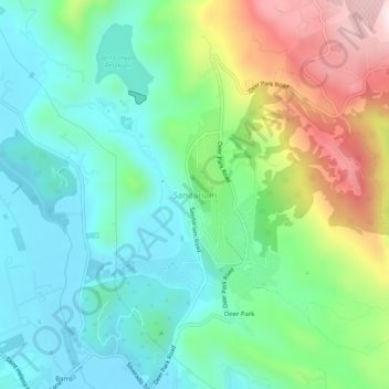
Name: Sanitarium topographic map, elevation, terrain.

Location: Sanitarium, Napa County, California, 94574, United States (38.52491 -122.49554 38.56491 -122.45554)

Average elevation: 214 m

Minimum elevation: 68 m

Maximum elevation: 546 m

Other topographic maps

Click on a map to view its topography, its elevation and its terrain.

Calistoga

United States > California > Napa County

Average elevation: 160 m

St. Helena

United States > California > Napa County

Average elevation: 111 m

Lake Berryessa

United States > California > Napa County

Average elevation: 322 m

Gear up for your next adventure:

🧤Insulated Winter Gloves - Heavy-duty protection for sub-zero Canadian adventures
🧥Packable Rain Jacket - Breathable waterproof layer for unpredictable weather
🔦LED Flashlight - Powerful and long-lasting flashlight for camping and emergencies
🥾Trekking Poles - Adjustable trekking poles to reduce knee stress and improve stability
🧢Hiking Hat - Sun-protective and breathable hats for long treks

As an Amazon Associate, this site earns from qualifying purchases at no extra cost to you.