
Make a donation
Gear up for your next adventure:
As an Amazon Associate, this site earns from qualifying purchases at no extra cost to you.
Burghaun topographic map
Click on the map to display elevation.
Make a donation
Gear up for your next adventure:
As an Amazon Associate, this site earns from qualifying purchases at no extra cost to you.
Burghaun
Weiterhin gibt es die Weiler Klausmarbach, Mahlertshof und Hartmannshöhe, die keinen Status als Ortsteil haben.
Make a donation
Gear up for your next adventure:
As an Amazon Associate, this site earns from qualifying purchases at no extra cost to you.
About this map
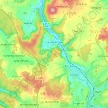
Name: Burghaun topographic map, elevation, terrain.
Location: Burghaun, Landkreis Fulda, Hessen, 36151, Deutschland (50.66747 9.60697 50.75205 9.77135)
Average elevation: 329 m
Minimum elevation: 226 m
Maximum elevation: 509 m
Make a donation
Gear up for your next adventure:
As an Amazon Associate, this site earns from qualifying purchases at no extra cost to you.
Other topographic maps
Click on a map to view its topography, its elevation and its terrain.