Geolocate

Nakuru topographic map

Click on the map to display elevation.

About this map

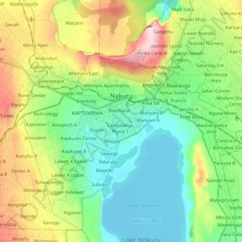
Name: Nakuru topographic map, elevation, terrain.

Location: Nakuru, Nakuru West, Nakuru, 20100, Kenya (-0.35975 36.01620 -0.25911 36.16339)

Average elevation: 1,893 m

Minimum elevation: 1,754 m

Maximum elevation: 2,257 m

Other topographic maps

Click on a map to view its topography, its elevation and its terrain.

Mwariki

Kenya > Nakuru > Nakuru West > Barut ward

Average elevation: 1,785 m

Barut ward

Kenya > Nakuru > Nakuru West

Average elevation: 1,888 m

Tulwapkogos

Kenya > Nakuru > Nakuru West > Kapkures ward

Average elevation: 1,972 m

Vertinary

Kenya > Nakuru > Nakuru West > London ward

Average elevation: 1,889 m

Railways Quaters

Kenya > Nakuru > Nakuru West > London ward

Average elevation: 1,888 m

Gear up for your next adventure:

🚲MTB Frame Bag - Carry tools and maps directly on your bicycle frame
🧢Beanie Hat - Keep your head warm in cold weather
🗺️Topographic Maps - Detailed maps to explore trails, mountains, and wilderness areas
🔦UV Flashlight - Detect minerals or specific insects in the dark
🎒Hiking Backpack - Lightweight and ergonomic backpacks for day hikes or multi-day treks

As an Amazon Associate, this site earns from qualifying purchases at no extra cost to you.