
Annaberg topographic map
Click on the map to display elevation.
About this map
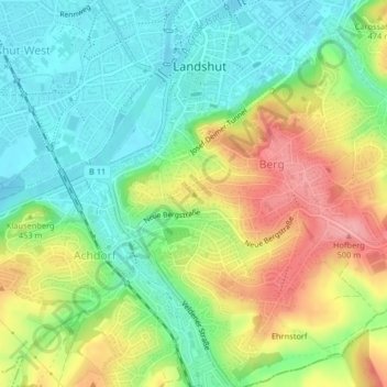
Name: Annaberg topographic map, elevation, terrain.
Location: Annaberg, Landshut, Bayern, 84028, Deutschland (48.52724 12.15100 48.52734 12.15110)
Average elevation: 432 m
Minimum elevation: 389 m
Maximum elevation: 497 m
Other topographic maps
Click on a map to view its topography, its elevation and its terrain.
Burg Trausnitz
Deutschland > Bayern > Landshut
Die Sporn- bzw. Höhenburg befindet sich im Zentrum des Unterbayerischen Hügellandes auf einer Höhe von über 500 m ü. NN, am höchsten Punkt, dem Sporn eines Steilhanges, der Hofberg genannt wird. Die Hochebene ist direkt über der Stadt Landshut und der Isar, in der Gemarkung Berg ob Landshut. Die Burg…
Average elevation: 426 m