Geolocate

Champclause topographic map

Click on the map to display elevation.

About this map

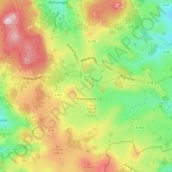
Name: Champclause topographic map, elevation, terrain.

Location: Champclause, Le Puy-en-Velay, Haute-Loire, Auvergne-Rhône-Alpes, Metropolitan France, France (44.99812 4.11105 45.05758 4.21225)

Average elevation: 1,204 m

Minimum elevation: 1,027 m

Maximum elevation: 1,416 m

Other topographic maps

Click on a map to view its topography, its elevation and its terrain.

Montbonnet

France > Auvergne-Rhône-Alpes > Haute-Loire > Bains

Average elevation: 1,115 m

Ville

France > Auvergne-Rhône-Alpes > Haute-Loire > Dunières

Average elevation: 887 m

Gear up for your next adventure:

🏃Hydration Running Vest - Carry water and maps close to your body for speed
🥾Hiking Boots - Sturdy boots providing ankle support and traction on rugged trails
🧳Compression Sacks - Maximize space in your backpack by shrinking gear
🔭Compact Monocular - One-handed bird watching and trail spotting
🛶Kayak Accessories - Essential gear for safe and fun kayaking adventures

As an Amazon Associate, this site earns from qualifying purchases at no extra cost to you.