
Jutogh topographic map
Click on the map to display elevation.
Jutogh
Jutogh is located at 31°06′N 77°07′E / 31.1°N 77.12°E / 31.1; 77.12 near Totu, an important suburb of Shimla city. It has an average elevation of 1729 metres (5673 feet), a total green area of 112.62 Acres, and a public garden known as Cantt. Board Public Garden.
About this map
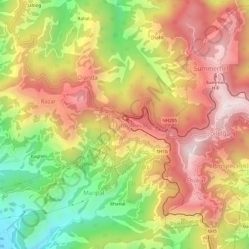
Name: Jutogh topographic map, elevation, terrain.
Location: Jutogh, Chakar, Shimla, Himachal Pradesh, 171005, India (31.08065 77.10193 31.12065 77.14193)
Average elevation: 1,785 m
Minimum elevation: 1,349 m
Maximum elevation: 2,150 m