Geolocate

Arjuno-Welirang topographic map

Click on the map to display elevation.

About this map

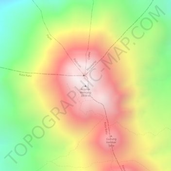
Name: Arjuno-Welirang topographic map, elevation, terrain.

Location: Arjuno-Welirang, Batu, East Java, Java, Indonesia (-7.73431 112.57494 -7.73421 112.57504)

Average elevation: 2,691 m

Minimum elevation: 2,159 m

Maximum elevation: 3,143 m

Other topographic maps

Click on a map to view its topography, its elevation and its terrain.

Alun-Alun Batu

Indonesia > East Java > Batu > Temas

Average elevation: 892 m

Alun-Alun Batu

Indonesia > East Java > Batu > Temas

Average elevation: 892 m

Gear up for your next adventure:

🦶Hiking Shoe Insoles - Added support for high arches and long days on feet
🧦Hiking Liner Socks - Thin base layer to prevent friction and blisters
💡Portable Camping Lamp - Rechargeable lamp for campsite lighting
🚲Bike Repair Kit - Essential tools for on-trail mechanical issues
🧴Insect Repellent - Protect yourself from bugs during outdoor adventures

As an Amazon Associate, this site earns from qualifying purchases at no extra cost to you.