
Poboleda topographic map
Click on the map to display elevation.
About this map
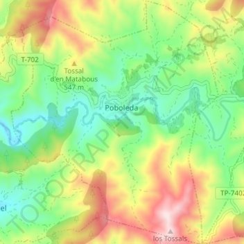
Name: Poboleda topographic map, elevation, terrain.
Location: Poboleda, Priorato, Tarragona, Cataluña, 43376, España (41.20761 0.81732 41.25342 0.86909)
Average elevation: 453 m
Minimum elevation: 271 m
Maximum elevation: 733 m
Other topographic maps
Click on a map to view its topography, its elevation and its terrain.
Parc Natural de la Serra de Montsant
España > Cataluña > Priorato > la Morera de Montsant
La cima de la Roca Corbatera de 1163 metros es la máxima altitud del parque.
Average elevation: 596 m
Cornudella de Montsant
España > Cataluña > Priorato > Cornudella de Montsant > Cornudella de Montsant
Average elevation: 584 m
Presa del Pantà de Siurana
España > Cataluña > Priorato > Cornudella de Montsant
Average elevation: 512 m