
Easton topographic map
Interactive map
Click on the map to display elevation.
About this map
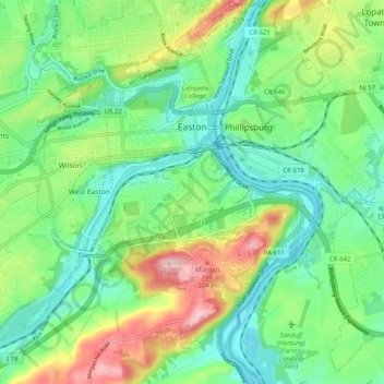
Name: Easton topographic map, elevation, terrain.
Location: Easton, Northampton County, Pennsylvania, United States (40.64074 -75.28374 40.71666 -75.19015)
Average elevation: 109 m
Minimum elevation: 43 m
Maximum elevation: 245 m
Other topographic maps
Click on a map to view its topography, its elevation and its terrain.
Bethlehem
United States > Pennsylvania > Northampton County
Bethlehem, Northampton County, Pennsylvania, United States
Average elevation: 120 m
Bangor
United States > Pennsylvania > Northampton County
Bangor, Northampton County, Pennsylvania, United States
Average elevation: 198 m
Allen Township
United States > Pennsylvania > Northampton County
Allen Township, Northampton County, Pennsylvania, 18067, United States
Average elevation: 139 m
Brodhead
United States > Pennsylvania > Northampton County > Bethlehem Township
Brodhead, Bethlehem Township, Northampton County, Pennsylvania, 18020, United States
Average elevation: 115 m
Williams Township
United States > Pennsylvania > Northampton County
Williams Township, Northampton County, Pennsylvania, United States
Average elevation: 131 m
Northwood Heights
United States > Pennsylvania > Northampton County > Palmer Township > Palmer Heights
Northwood Heights, Palmer Heights, Palmer Township, Northampton County, Pennsylvania, 18045, United States
Average elevation: 110 m
Mount Bethel
United States > Pennsylvania > Northampton County > Upper Mount Bethel Township
Mount Bethel, Upper Mount Bethel Township, Northampton County, Pennsylvania, 18351, United States
Average elevation: 156 m
Hellertown
United States > Pennsylvania > Northampton County
Hellertown, Northampton County, Pennsylvania, United States
Average elevation: 107 m
Bethlehem
United States > Pennsylvania > Northampton County > Bethlehem
Bethlehem, Northampton County, Pennsylvania, 18108, United States
Average elevation: 149 m
Bushkill Township
United States > Pennsylvania > Northampton County > Bushkill Township
Bushkill Township, Northampton County, Pennsylvania, 18091, United States
Average elevation: 214 m
Newport
United States > Pennsylvania > Northampton County > Newport
Newport, Northampton, Northampton County, Pennsylvania, 18037, United States
Average elevation: 113 m
Nazareth
United States > Pennsylvania > Northampton County > Nazareth
Nazareth, Northampton County, Pennsylvania, United States
Average elevation: 149 m
Wind Gap
United States > Pennsylvania > Northampton County
Wind Gap, Northampton County, Pennsylvania, United States
Average elevation: 255 m