Geolocate

Batesville topographic map

Click on the map to display elevation.

About this map

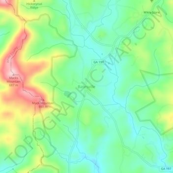
Name: Batesville topographic map, elevation, terrain.

Location: Batesville, Habersham County, Georgia, United States (34.72815 -83.63128 34.76815 -83.59128)

Average elevation: 534 m

Minimum elevation: 462 m

Maximum elevation: 672 m

Other topographic maps

Click on a map to view its topography, its elevation and its terrain.

Baldwin

United States > Georgia > Habersham County

Average elevation: 395 m

Demorest

United States > Georgia > Habersham County

Average elevation: 416 m

Gear up for your next adventure:

🛌Down Sleeping Bag - Superior warmth-to-weight ratio for cold nights
🥾Hiking Leggings - Comfortable leggings for outdoor activities
🔋Emergency Crank Radio - Weather alerts and power without needing batteries
🎒Hiking Daypack - Lightweight and durable backpacks for day trips and excursions
🔋Lithium AA Batteries - Long-lasting power that performs in extreme cold

As an Amazon Associate, this site earns from qualifying purchases at no extra cost to you.