Geolocate

Pajagan topographic map

Click on the map to display elevation.

About this map

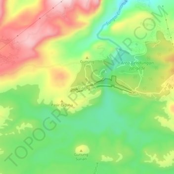
Name: Pajagan topographic map, elevation, terrain.

Location: Pajagan, Sumedang, West Java, Java, Indonesia (-6.87682 108.07051 -6.83682 108.11051)

Average elevation: 253 m

Minimum elevation: 105 m

Maximum elevation: 442 m

Other topographic maps

Click on a map to view its topography, its elevation and its terrain.

Waduk Jatigede

Indonesia > West Java > Sumedang > Sukakersa

Average elevation: 295 m

Waduk Jatigede

Indonesia > West Java > Sumedang > Pajagan

Average elevation: 234 m

Gear up for your next adventure:

🪑Insulated Seat Pad - Protect your seat from cold rocks and wet logs
🧼Travel Hand Sanitizer - Keep hands clean when water is scarce
🚑Survival Whistle - Signal for help across long distances in mountains
🧢Outdoor Visor - Breathable visor for sunny hikes
🧥Insulated Jacket - Keep warm in cold outdoor conditions

As an Amazon Associate, this site earns from qualifying purchases at no extra cost to you.