
Make a donation
Gear up for your next adventure:
As an Amazon Associate, this site earns from qualifying purchases at no extra cost to you.
Rocky Mount topographic map
Click on the map to display elevation.
Make a donation
Gear up for your next adventure:
As an Amazon Associate, this site earns from qualifying purchases at no extra cost to you.
About this map
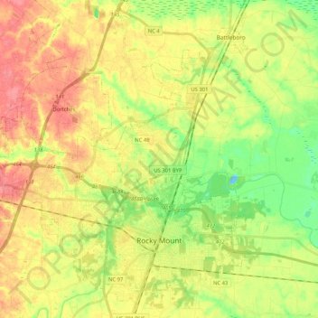
Name: Rocky Mount topographic map, elevation, terrain.
Location: Rocky Mount, Nash County, North Carolina, United States (35.90156 -77.90394 36.06610 -77.73565)
Average elevation: 38 m
Minimum elevation: -4 m
Maximum elevation: 72 m
Make a donation
Gear up for your next adventure:
As an Amazon Associate, this site earns from qualifying purchases at no extra cost to you.
Other topographic maps
Click on a map to view its topography, its elevation and its terrain.
Rocky Mount Millpond Dam
United States > North Carolina > Nash County > Rocky Mount
Average elevation: 32 m
Make a donation
Gear up for your next adventure:
As an Amazon Associate, this site earns from qualifying purchases at no extra cost to you.
Brook Valley Trailer Park
United States > North Carolina > Nash County > Rocky Mount > Brook Valley Trailer Park
Average elevation: 48 m