Geolocate

Greenbrier topographic map

Click on the map to display elevation.

About this map

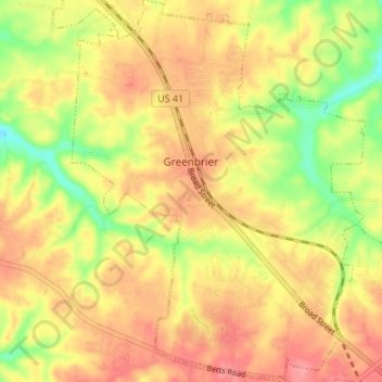
Name: Greenbrier topographic map, elevation, terrain.

Location: Greenbrier, Robertson County, Middle Tennessee, Tennessee, 37073, United States (36.39635 -86.82574 36.45039 -86.77394)

Average elevation: 244 m

Minimum elevation: 196 m

Maximum elevation: 277 m

Other topographic maps

Click on a map to view its topography, its elevation and its terrain.

Gear up for your next adventure:

🥾Light Trekking Boots - Supportive boots for multi-day treks
🥾Trekking Poles - Adjustable trekking poles to reduce knee stress and improve stability
🎒Hiking Daypack - Lightweight and durable backpacks for day trips and excursions
🧊Portable Cooler - Keep food and drinks cold during outdoor adventures
🥾Hiking Gaiters - Protect legs and shoes from mud, snow, and debris

As an Amazon Associate, this site earns from qualifying purchases at no extra cost to you.