
Make a donation
Gear up for your next adventure:
As an Amazon Associate, this site earns from qualifying purchases at no extra cost to you.
Wachtebeke topographic map
Click on the map to display elevation.
Make a donation
Gear up for your next adventure:
As an Amazon Associate, this site earns from qualifying purchases at no extra cost to you.
Wachtebeke
Wachtebeke ligt in Zandig Vlaanderen op een hoogte van 4 tot 7 meter. Ten zuiden van de kern ligt de Moervaartdepressie tussen de Moervaart in het noorden en de Zuidlede in het zuiden. Ook vindt men daar het Provinciaal Domein Puyenbroeck. In het noordoosten ligt het Heidebos terwijl in het noordwesten het Kloosterbos te vinden is. In het westen ligt industrie met onder meer de staalfabrieken van ArcelorMittal-Gent en het Kanaal Gent-Terneuzen.
Make a donation
Gear up for your next adventure:
As an Amazon Associate, this site earns from qualifying purchases at no extra cost to you.
About this map
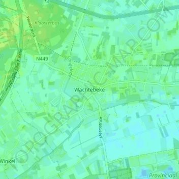
Name: Wachtebeke topographic map, elevation, terrain.
Location: Wachtebeke, Gent, Oost-Vlaanderen, Vlaanderen, 9185, België (51.15019 3.83743 51.19019 3.87743)
Average elevation: 5 m
Minimum elevation: -3 m
Maximum elevation: 11 m
Make a donation
Gear up for your next adventure:
As an Amazon Associate, this site earns from qualifying purchases at no extra cost to you.