
Arroyo La Carbonera topographic map
Interactive map
Click on the map to display elevation.
About this map
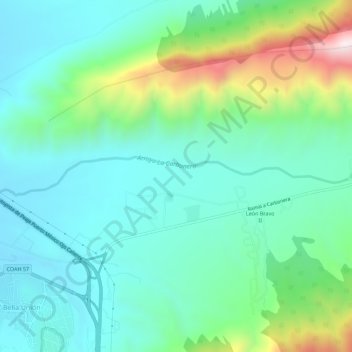
Name: Arroyo La Carbonera topographic map, elevation, terrain.
Location: Arroyo La Carbonera, Arteaga, Coahuila, 22350, México (25.45003 -100.82164 25.45551 -100.76564)
Average elevation: 1,921 m
Minimum elevation: 1,710 m
Maximum elevation: 2,581 m
Other topographic maps
Click on a map to view its topography, its elevation and its terrain.
El Diamante
El Diamante, Arteaga, Coahuila, México
Average elevation: 2,184 m
Arroyo La Carbonera
Arroyo La Carbonera, Arteaga, Coahuila, México
Average elevation: 2,167 m
San Antonio de Las Alazanas
San Antonio de Las Alazanas, Arteaga, Coahuila, México
Average elevation: 2,203 m
Los Lirios
Los Lirios, Arteaga, Coahuila, México
Average elevation: 2,498 m