Geolocate

Shahada topographic map

Click on the map to display elevation.

About this map

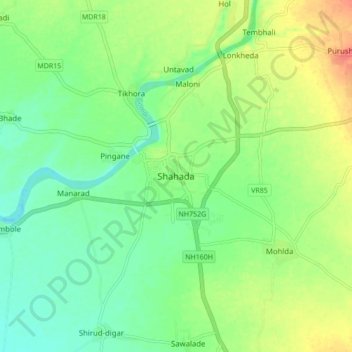
Name: Shahada topographic map, elevation, terrain.

Location: Shahada, Shahada Taluka, Nandurbar, Maharashtra, 425409, India (21.50092 74.43166 21.58092 74.51166)

Average elevation: 140 m

Minimum elevation: 120 m

Maximum elevation: 172 m

Gear up for your next adventure:

🥾Approach Boots - Comfortable boots for hiking and climbing approaches
🎒Backpack Rain Cover - External shield to keep your entire pack dry
🧦Merino Wool Socks - Moisture-wicking comfort for long-distance hiking
🥾Hiking Leggings - Comfortable leggings for outdoor activities
💧Collapsible Water Bottle - Space-saving water bottle for outdoor activities

As an Amazon Associate, this site earns from qualifying purchases at no extra cost to you.