
Make a donation
Gear up for your next adventure:
As an Amazon Associate, this site earns from qualifying purchases at no extra cost to you.
Philipsburg topographic map
Click on the map to display elevation.
Make a donation
Gear up for your next adventure:
As an Amazon Associate, this site earns from qualifying purchases at no extra cost to you.
About this map
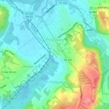
Name: Philipsburg topographic map, elevation, terrain.
Location: Philipsburg, Centre County, Pennsylvania, United States (40.87916 -78.22748 40.90637 -78.20467)
Average elevation: 456 m
Minimum elevation: 431 m
Maximum elevation: 519 m
Make a donation
Gear up for your next adventure:
As an Amazon Associate, this site earns from qualifying purchases at no extra cost to you.
Other topographic maps
Click on a map to view its topography, its elevation and its terrain.
Dalevue Park
United States > Pennsylvania > Centre County > State College > Dalevue
Average elevation: 331 m
Make a donation
Gear up for your next adventure:
As an Amazon Associate, this site earns from qualifying purchases at no extra cost to you.
Loch Lomond Junction
United States > Pennsylvania > Centre County > Rush Township
Average elevation: 460 m