
Holiday Poconos topographic map
Click on the map to display elevation.
About this map
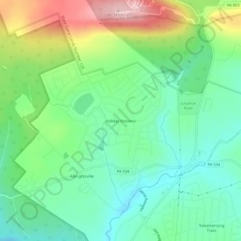
Name: Holiday Poconos topographic map, elevation, terrain.
Average elevation: 519 m
Minimum elevation: 448 m
Maximum elevation: 663 m
Other topographic maps
Click on a map to view its topography, its elevation and its terrain.
Lake Harmony
United States > Pennsylvania > Carbon County > Kidder Township > Lake Harmony
Average elevation: 568 m
Hickory Run State Park
United States > Pennsylvania > Carbon County > Kidder Township
Average elevation: 471 m