
Make a donation
Gear up for your next adventure:
As an Amazon Associate, this site earns from qualifying purchases at no extra cost to you.
Aluva topographic map
Click on the map to display elevation.
Make a donation
Gear up for your next adventure:
As an Amazon Associate, this site earns from qualifying purchases at no extra cost to you.
Aluva
Aluva Railway Station is a major stop for trains that passes north to south of Kerala. It is the third busiest station in Kochi city, after Ernakulam Junction railway station and Ernakulam Town railway station. The station is important for southern railway because of the number of passengers itself. The commuters and travellers from Idukki district have to use either this station or the Tripunithura railway station for all their train journeys as there is no possible railway in the Idukki topography. There are no trains starting or ending at this station, but there are a lot of trains which stop for considerable duration here.
Make a donation
Gear up for your next adventure:
As an Amazon Associate, this site earns from qualifying purchases at no extra cost to you.
About this map
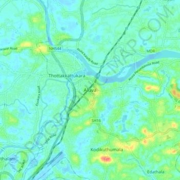
Name: Aluva topographic map, elevation, terrain.
Location: Aluva, Ernakulam, Kerala, 683101, India (10.06777 76.31685 10.14777 76.39685)
Average elevation: 11 m
Minimum elevation: -2 m
Maximum elevation: 52 m
Make a donation
Gear up for your next adventure:
As an Amazon Associate, this site earns from qualifying purchases at no extra cost to you.
Other topographic maps
Click on a map to view its topography, its elevation and its terrain.