
Make a donation
Gear up for your next adventure:
As an Amazon Associate, this site earns from qualifying purchases at no extra cost to you.
Katun Popadija topographic map
Click on the map to display elevation.
Make a donation
Gear up for your next adventure:
As an Amazon Associate, this site earns from qualifying purchases at no extra cost to you.
About this map
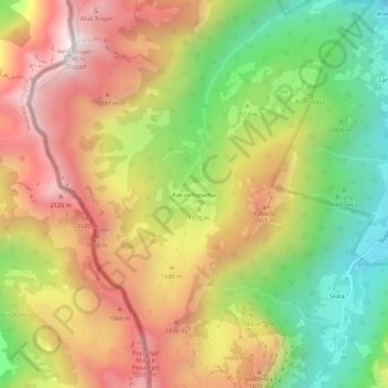
Name: Katun Popadija topographic map, elevation, terrain.
Location: Katun Popadija, Gusinje Municipality, Montenegro (42.51579 19.74660 42.55579 19.78660)
Average elevation: 1,598 m
Minimum elevation: 1,038 m
Maximum elevation: 2,156 m
Make a donation
Gear up for your next adventure:
As an Amazon Associate, this site earns from qualifying purchases at no extra cost to you.
Other topographic maps
Click on a map to view its topography, its elevation and its terrain.
Accursed Mountains
Montenegro > Gusinje Municipality
The Accursed Mountains are a typical Dinaric karst high mountain range with a pronounced steep topography and glacial features. Maximum relief differences of 1,800 metres (5,900 ft) are found in the Valbona, Grbaja and Ropojani and Cem valleys. Overhanging walls and ridges forming pointed peaks are typical of…
Average elevation: 1,676 m