
Mussoorie topographic map
Click on the map to display elevation.
Mussoorie
Mussoorie is at an average altitude of 2,005 metres (6,578 ft). To the northeast are the Himalayan snow ranges, and to the south, the Doon Valley and Sivalik Hills ranges. The second highest point is the original Lal Tibba in Landour, with a height of over 2,275 m (7,464 ft). Mussoorie is popularly known as The Queen of the Hills.
About this map
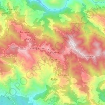
Name: Mussoorie topographic map, elevation, terrain.
Location: Mussoorie, Dehradun, Uttarakhand, 248179, India (30.41690 78.03829 30.49690 78.11829)
Average elevation: 1,594 m
Minimum elevation: 878 m
Maximum elevation: 2,285 m