Geolocate

Evans topographic map

Click on the map to display elevation.

About this map

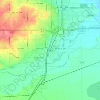
Name: Evans topographic map, elevation, terrain.

Location: Evans, Colorado, 80631-6948, United States (40.33637 -104.73219 40.41637 -104.65219)

Average elevation: 1,430 m

Minimum elevation: 1,405 m

Maximum elevation: 1,487 m

Gear up for your next adventure:

🛏️Camping Sleeping Mat - Comfortable mats for sleeping outdoors
🥤Collapsible Travel Cup - Saves space and weight in your mess kit
🔨Vehicle Emergency Tool - Safety tool for remote road trips to trailheads
🥾Light Trekking Boots - Supportive boots for multi-day treks
🚑Survival Whistle - Signal for help across long distances in mountains

As an Amazon Associate, this site earns from qualifying purchases at no extra cost to you.