
Thank you for supporting this site ❤️
Make a donation
Make a donation
Gear up for your next adventure:
As an Amazon Associate, this site earns from qualifying purchases at no extra cost to you.
Supatá topographic map
Click on the map to display elevation.
Thank you for supporting this site ❤️
Make a donation
Make a donation
Gear up for your next adventure:
As an Amazon Associate, this site earns from qualifying purchases at no extra cost to you.
About this map
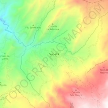
Name: Supatá topographic map, elevation, terrain.
Location: Supatá, Gualivá, RAP (Especial) Central, 253667, Colombia (5.02217 -74.27640 5.10217 -74.19640)
Average elevation: 1,982 m
Minimum elevation: 1,243 m
Maximum elevation: 2,889 m
Thank you for supporting this site ❤️
Make a donation
Make a donation
Gear up for your next adventure:
As an Amazon Associate, this site earns from qualifying purchases at no extra cost to you.