Geolocate

Alins topographic map

Click on the map to display elevation.

About this map

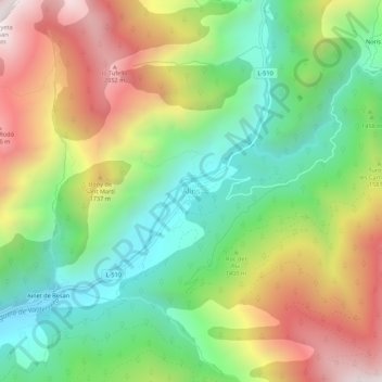
Name: Alins topographic map, elevation, terrain.

Location: Alins, Pallars Sobirá, Lérida, Cataluña, España (42.52912 1.29806 42.56912 1.33806)

Average elevation: 1,465 m

Minimum elevation: 982 m

Maximum elevation: 2,147 m

Gear up for your next adventure:

🌡️Emergency Mylar Blankets - Compact thermal protection for unexpected nights outdoors
🛏️Camping Sleeping Mat - Comfortable mats for sleeping outdoors
🧭GPS Tracker - Track your location in remote areas safely
🚲Handlebar Phone Mount - View topographic-map.com live while cycling
🔦LED Headlamp - Hands-free lighting for early morning starts or late finishes

As an Amazon Associate, this site earns from qualifying purchases at no extra cost to you.